La Maplouine LaMaplouine Le guide ultime pour explorer Saint-MaloThe ultimate Saint-Malo tour guide

Les lieux, leur histoire, les raisons.

The places, their history, the reasons.

Plus de 900 notices géolocalisées à Saint-Malo, sur la Rance et dans le Clos-Poulet, chacune contenant une information que vous ne saviez pas. Érudite et ludique, La Maplouine est la carte interactive des explorateurs qui désirent comprendre et connaître la cité corsaire au-delà des lieux communs. Accessible via Google Maps, son utilisation est pratique et facile.

More than 900 geolocated notes in Saint-Malo, along the Rance and across the Clos-Poulet, each carrying something you did not know. Scholarly and playful, La Maplouine is the interactive map for explorers who want to know the corsair city beyond the received ideas. It runs in Google Maps, so it is easy and practical to use.

L'unique carte interactive du patrimoine et de l'histoire malouine. Mises à jour régulières incluses, sans création de compte et sans application à installer.

The only interactive map of the heritage and history of Saint-Malo. Regular updates included, no account to create and no app to install.

900 +

notices, de la ville close à la haute Rance et au marais de Dol

notes, from the walled town to the upper Rance and the Dol marsh

10

catégories : malouinières, églises, forts, îles, moulins, rues…

categories: manors, churches, forts, islands, mills, streets…

2

langues, toute la carte en français et en anglais

languages, the whole map in French and in English

Trois notices, en entier

Three notes, in full

Des notices géolocalisées concises, passionnantes pour comprendre et vivre la cité corsaire.

Concise geolocated notes, made to understand and to live the corsair city.


Intra-Muros

Piscine de Bon-Secours

Bassin de mer aménagé en 1936 contre la grève de Bon-Secours, fermé par un mur de béton et pourvu d'un plongeoir. Le principe appartient aux côtes à fort marnage : la digue retient l'eau quand la mer se retire, de sorte que le bassin reste plein pendant les heures où la plage est à sec, et qu'il se renouvelle seul à chaque pleine mer. L'ouvrage relève de la génération d'équipements balnéaires des années trente, contemporaine du percement de la poterne d'Estrées, quand la ville close achève de convertir son estran militaire en front de baignade.

A sea-water basin laid out in 1936 against the strand of Bon-Secours, closed by a concrete wall and fitted with a diving board. The principle belongs to coasts with a great tidal range: the wall holds the water back as the sea withdraws, so that the basin stays full during the hours when the beach is dry, and renews itself at every high tide. The work belongs to the generation of seaside facilities of the nineteen-thirties, contemporary with the cutting of the poterne d'Estrées, when the walled town was finishing the conversion of its military foreshore into a bathing front.

📍 48.6486, −2.0303

Forts et îles

Le Pouilloux

Écueil découvrant au large de la grève de Bon-Secours, entre le pied des remparts et le Grand Bé. Il appartient au chapelet de roches qui a longtemps rendu le mouillage de Saint-Malo praticable seulement pour qui en connaissait le tracé, avantage défensif que la ville a soigneusement entretenu : les pilotes malouins étaient une profession fermée. À basse mer, il émerge d'un estran de sable et de roches où l'on marche jusqu'aux îlots ; à pleine mer, il disparaît complètement.

A drying reef off the strand of Bon-Secours, between the foot of the ramparts and the Grand Bé. It belongs to the string of rocks that long made the anchorage of Saint-Malo practicable only for those who knew the way through, a defensive advantage the town carefully maintained: the pilots of Saint-Malo were a closed profession. At low water it emerges from a foreshore of sand and rock across which one walks out to the islets; at high water it disappears entirely.

📍 48.6491, −2.0301

Paramé

Manoir de la Grande Barbinais

Manoir de la route de Château-Malo, devenu ferme et défiguré par un second étage ajouté sous l'Empire. La terre appartenait à la famille Porcon, dont Pierre Porcon de la Barbinais a laissé le souvenir sous le nom de Régulus malouin : prisonnier du dey d'Alger, chargé de porter à Louis XIV des propositions de paix, il serait revenu reprendre ses fers comme il l'avait juré et aurait eu la tête tranchée en 1681. Le récit ne paraît qu'en 1824 chez Manet ; aucun texte du XVIIe siècle ne le mentionne et les historiens y voient une légende édifiante. Le seul La Barbinais attesté dans ce rôle est Luc Trouin, frère aîné de Duguay-Trouin, esclave au Maroc et envoyé négocier un échange de captifs en 1689 : sa mission réussit.

A manor on the Château-Malo road, now a farm, disfigured by a second storey added under the Empire. The land belonged to the Porcon family, of whom Pierre Porcon de la Barbinais left a memory under the name of the Saint-Malo Regulus: a prisoner of the Dey of Algiers, charged with carrying peace proposals to Louis XIV, he is said to have come back to resume his chains as he had sworn, and to have been beheaded in 1681. The story appears only in 1824, in Manet; no seventeenth-century text mentions it and historians regard it as an edifying legend. The only La Barbinais attested in such a role is Luc Trouin, elder brother of Duguay-Trouin, a slave in Morocco sent to negotiate an exchange of captives in 1689: his mission succeeded.

📍 48.6455, −1.9611

Essayer avant d'acheter

Try before you buy

Cinquante lieux, gratuits, tout de suite.

Fifty places, free, right now.


Cinq lieux dans chacune des dix catégories, pris dans treize zones différentes, pour que vous voyiez l'étendue plutôt qu'un coin : des remparts et des églises, bien sûr, mais aussi une briqueterie, un camp viking, la balise de Rochefort, un écueil qui disparaît à pleine mer.

Five places in each of the ten categories, taken from thirteen different areas, so you see the range rather than one corner of it: ramparts and churches, of course, but also a brickworks, a Viking camp, the Rochefort beacon, a reef that vanishes at high water.

Les lieux de La Maplouine, de la ville close à la haute Rance
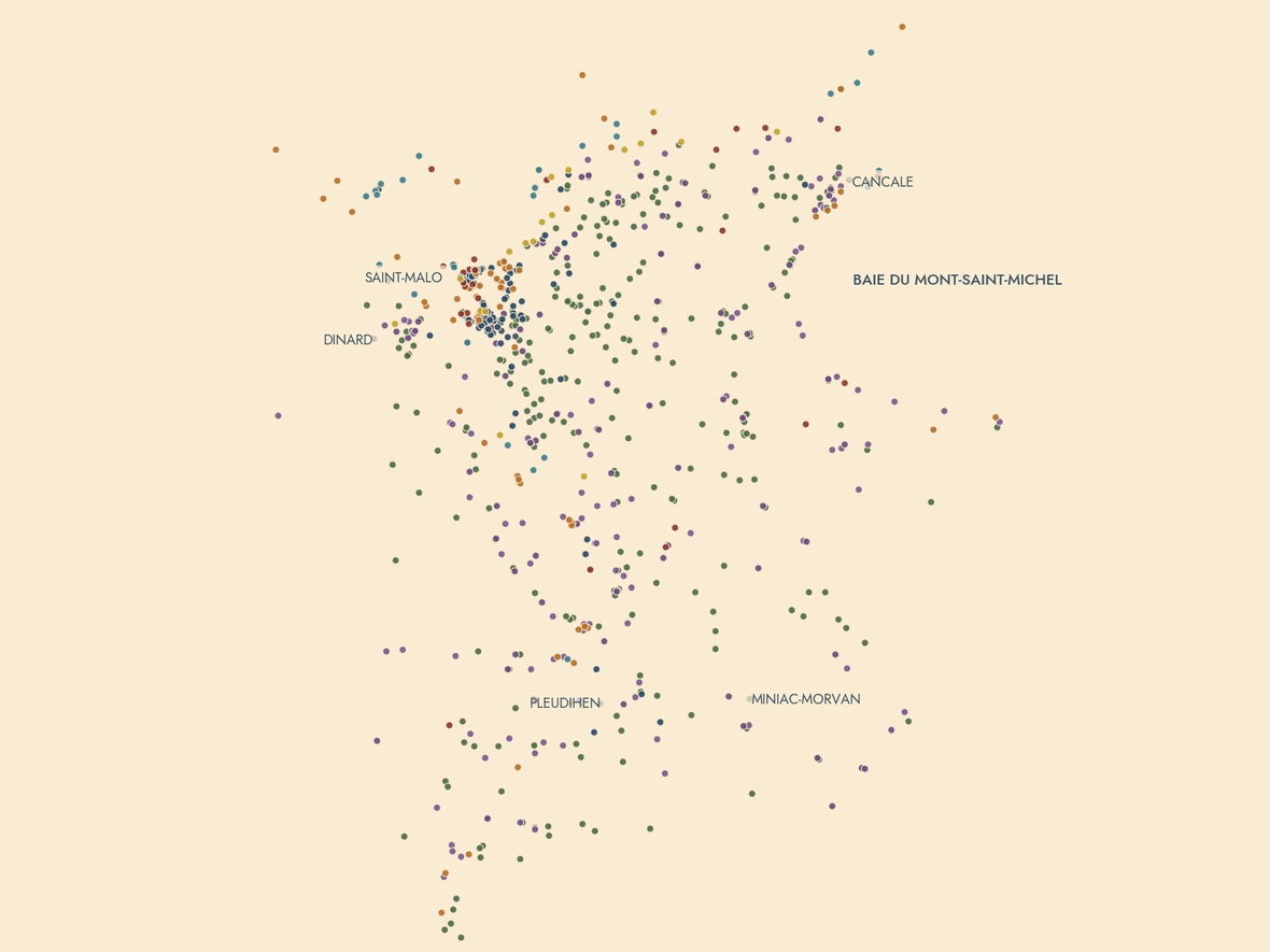
Saint-Malo, la Rance et le Clos-Poulet vus par les pastilles de La Maplouine : une par notice, la couleur donne la catégorie, sans aucun fond de carte.
Saint-Malo, the Rance and the Clos-Poulet seen through the pinpoints of La Maplouine: one per note, the colour gives the category, with no base map at all.

Personne ne paie pour y figurer

Nobody pays to be on it

Pas de publicité. Pas de sponsorisation. Totalement indépendante.

No advertising. No sponsorship. Wholly independent.


Aucune publicité

No advertising

Pas de bannière, pas de lien partenaire. Vous payez une fois, et devenez propriétaire de votre carte, régulièrement mise à jour.

No banner, no partner link. You pay once, and the map is yours — kept up to date for good.

Aucune sponsorisation

No sponsorship

Un lieu y est parce qu'il vaut le détour, ou il n'y est pas.

A place is there because it is worth the detour, or it is not there.

Totalement indépendante

Wholly independent

Nous ne sommes pas un office de tourisme, une agence ou un hôtel, mais des Malouins passionnés par l'histoire de leur ville et ayant à cœur de la partager entière et sans filtres.

We are not a tourist board, an agency or a hotel, but Malouins taken with the history of their town and set on sharing it whole and unfiltered.

Carte de démonstration

Demonstration map

Gratuit
Free
  • 50 lieux, cinq par catégorie
  • 50 places, five per category
  • La notice entière pour chacun
  • The full note for each one
  • S'ouvre dans Google Maps
  • Opens in Google Maps
  • Français et anglais
  • French and English
Choisir une langue Choose a language

Carte complète

Full map

9 €
  • Plus de 900 notices : Saint-Malo, la Rance et le Clos-Poulet
  • More than 900 notes: Saint-Malo, the Rance and the Clos-Poulet
  • Cancale, Dinard, Dinan, le marais de Dol, les forts et les îles
  • Cancale, Dinard, Dinan, the Dol marsh, the forts and the islands
  • Mises à jour incluses, définitivement
  • Updates included, for good
  • Français et anglais
  • French and English
Bientôt disponible Available soon

Paiement sécurisé par Stripe, TVA comprise. Le lien vous parvient par courriel dans la foulée. La carte sera mise en vente prochainement.

Secure payment by Stripe, VAT included. The link reaches you by e-mail straight away. The map opens for sale shortly.

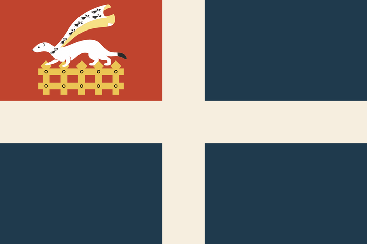
Le drapeau de Saint-Malo : croix blanche sur champ bleu, canton rouge à l'hermine passante et à la herse d'or
Le drapeau malouin : un pavillon de mer, né du bleu à croix blanche de la marine marchande et du rouge des corsaires du roi.
The flag of Saint-Malo: a sea flag, born of the merchant navy's blue and white cross and the red of the king's privateers.

Qui sommes-nous

Who we are

Compilée par une équipe de Malouins passionnés.

Compiled by a team of passionate Malouins.


La Maplouine est faite par une équipe de Malouins passionnés, tout autant de la grande histoire de course et de découverte que des petites anecdotes, de la vie des habitants de toute condition, des malouinières, des marées, de la reconstruction. Remparts, forts, églises, manoirs, moulins, îles, plages, rues et plaques — tous les aspects du pays malouin, réunis au même endroit et consultables au fil de votre visite.

La Maplouine is made by a team of passionate Malouins — as taken with the great history of privateering and discovery as with the small anecdotes, the lives of the inhabitants of every condition, the manor houses, the tides, the rebuilding. Ramparts, forts, churches, manors, mills, islands, beaches, streets and plaques — every aspect of the Saint-Malo country, gathered in one place and read as you go.

La carte s'enrichit régulièrement et chaque mise à jour vous parvient : achetez-la une fois et à vie, elle continuera de grandir.

The map grows regularly and every update reaches you: buy it once, for life, and it will keep growing.